The pro-government segments of the Indian media are committed to belittling Nepal's claims over the territory that India has occupied illegally for over five decades. However, this is no time to be drawn to any verbal duels that can jeopardize our relationship with India. It is only wise for Nepal to create a conducive environment for continuous bilateral dialogues with the neighbour, and Nepal can only afford diplomatic discussion with India to resolve this dispute. Hence, Nepal should right away start extensive homework in order to garner sufficient and conclusive evidence – which it requires if it is to make its case across the table.
As such, the Sugauli Treaty, signed with the then East India Company, is the basic document to support Nepal’s claims. But there are also numerous documents, reports and maps published at different times that lend credence to Nepal’s irrefutable claims. Based on various past cartographic evidence, Nepal can validate that the headwaters of the Kali River are at Limpiyadhura, and that from the east of the Kali river, the entire land of Limpiyadhura, Lipulekh and Kalapani belongs to Nepal.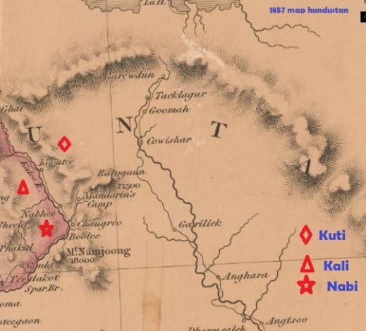
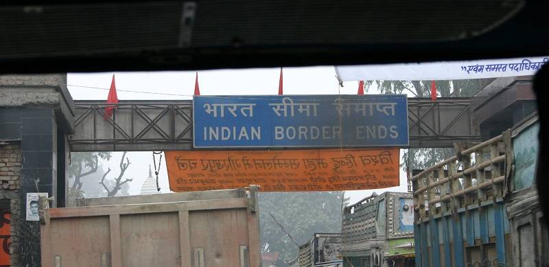
In November 2019, Nepal raised a serious objection when India unveiled a new map that included Limpiyadhura-Kalapani-Lipulekh, the border point of Nepal with India and China. The message from Nepal’s Ministry of Foreign Affairs was loud and clear: one that rejected India’s cartographic aspirations. Nepal also displayed a certain diplomatic wisdom by suggesting that dialogue is a way out in this situation to resolve outstanding issues of border delimitation. However, neglecting Nepal’s concerns, when India’s defense minister inaugurated a road to Mansharovar, the dispute has seen a tipping point. Nepal has responded with a new map of Nepal that depicts Limpiyadhura, Lipulekh and Kalapani as its territories.
After the Treaty of Sugauli (04 March, 1816), Nepal ceded the land on the other side (west) of Kali River (Mahakali) to British Empire. After the treaty, from 1815 to 1821, the British Surveyor Company had worked to delineate the border between Nepal and India, and it drew the map. This map, on page 45 of the 1816 report, which can be accessed from Historical Survey of India Library, shows the origin of the river Kali is Limpiyadhura. The recently issued map of Nepal is similar to that of 1816 prepared by the British Surveyor Company. (Improved Map of India, 02 January, 1816) This is the first available record of Nepal’s map after the treaty of Sugauli. As there is no historical record of Nepal ceding its land after the treaty of Sugauli, this map can be seen as conclusive and decisive evidence to establish the fact that the Kali River starts from Limpiyadhura.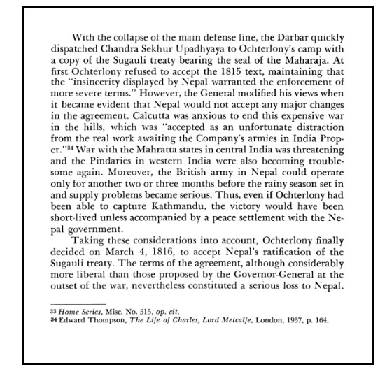
At this moment, it is worth recalling the historical background that propelled Nepal to sign the treaty of Sugauli itself. It is no secret that Nepal was unwilling to sign this treaty. The then East India Company sent the Treaty of Sugauli on the 2nd of December 1815 and asked Nepal to deliver the signed copy within 15 days. This was the second attempt by the Company after its unsuccessful attempt to make Nepal agree on the previous draft from the 2nd of October 1815. It was quite understandable that Nepal wanted to delay or avoid the signing of the treaty since signing of the paper sent by the Company would seal the fate of Nepal, deprive it of its land on the other side of the river Kali – Kumaon and Sutlej. It is said that Nepal even objected to the draft treaty and asked for a more fair treatment but Nepal’s fate was sealed after the Company threatened to attack Kathmandu.
Though the preliminary assessment from the Company was that it would be difficult to launch an immediate attack on Kathmandu during the rainy season, Company was keen to finalise the treaty at the earliest because in absence of a formal treaty, Nepal could claim back the lost territory or open the attack at any time later. Company was in no mood to linger the dispute in this region as its goals to establish the Raj within India was more important to it.
From Nepal’s view too, it was difficult to defeat the East India Company with depleted forces and lack of proper military preparation. Had the East India Company attacked the capital, Nepal would have to be content with land on the east of the river Kali with Lipulekh, Limpiyadhura and Kalapani on its side. This is how Nepal’s fate was sealed on the 4th of March, 1816. The treaty forced Nepal to abandon all claims over the territory on the other side of the river Kali, and some portions of Tarai region. The ratification of the treaty created a binding legal constraint on the successors of the reigning rulers of that time with respect to the lost territories. (Source: Nepal; Strategy for Survival by Leo E. Rose)
The finalization of the Sugauli Treaty was the culmination of a frequent exchange of correspondences between the King of Nepal Gajaraj Mishra, his representative Chandra Sekhar Upadhyaya and Lieutenant Colonel Paris Bradshaw representing the British, I.e. the then East India Company. (Source: Papers respecting the Nepaul war, Author: East India Company, Publisher: [London]: J.L. Cox, [1824])
On the 10th of December 1916, Nepal entered into a supplementary treaty with British India to receive back some land on the Tarai region spanning from Koshi to Rapti and from Morang to Dang.
Limpiyadhura as origin of Kali River
From the records and archives, it can be seen that the Kali River starts flowing from Limpiyadhura. The map published by British India in 1856 reveals that the Kali River originating at Limpiyadhura was named “Kuti Yangdi”. Later, the River flowing down from the west of Lipulekh, from Girphu, was called Kali. After 1969, India has created an artificial river at Kalapani, allowing it to flow down to be connected with Kali River. With this artificially created river, India has tried to give a semblance of legitimacy over the illegally occupied land of Nepal. Kalapani and Lipulekh are Nepali territories in Darchula District, Vyas Village Municipality but Nepal’s presence is nil there for the past five decades, due to illegal occupation by India. Limpiyadhura and Lipulekh – both lying further west of Kalapani – are also completely and illegally controlled by India.
Lipulekh is located at 17,000 ft. and it is a border point between Nepal and Tibet, autonomous region of China. The whole controversy on the illegal occupation of Limpiyadhura-Lipulekh-Kalapani has flared up after the news that India is constructing road on Lipulekh to join India with Mansharovar, Tibet. Indian Prime Minister Nehru, on the apparent request of the then PM of Nepal Matrika Prasad Koirala, had sent armies to Kathmandu on the pretext of modernization of the Nepal Army. These Indian armies, instead of returning to India after the completion of the task that was supposed to be over within one year, stayed in Nepal for more than 18 years. It was only with the continuous effort by Nepal’s Prime Minister Kirti Nidhi Bishta that the Indian Army started pulling out of Nepal in 1969.
The diplomatic maneuver by Nepal’s Prime Minister Kirti Nidhi Bishta at that time is another story with its own sub-plots. After India ignored the frequent requests of Nepal made through diplomatic channels, Prime Minister Kirti Nidhi Bishta had to orchestrate an interview with The Rising Nepal, a daily newspaper from Kathmandu, on the 25th of June 1969. In that interview, Prime Minister Kirti Nidhi Bishta clearly outlined, despite India’s dismay, his arguments for the withdrawal of the Indian Army from all 18 posts. The Indian establishment reluctantly removed its armies from 17 out of 18 posts, but Indians continued to stay at Tilshi Valley in Kalapani. Later, India took several measures in the most wicked manner to change the territory of Nepal. It has renamed a small river at Kalapani as Mahakali, and has tried to portray Kalapani as the origin point for River Mahakali. It has also constructed a small Kali Temple there. This is how India has tried to change the boundary of Nepal.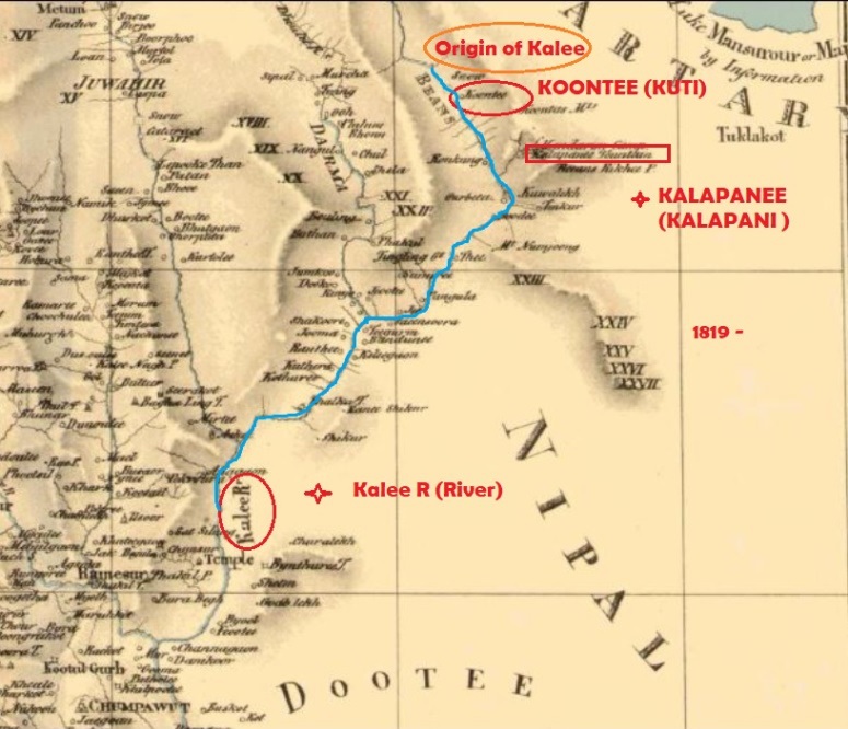
As per the Nepal-China Treaty of 1960, it emerges without any iota of doubt that China has clearly recognized and respected the fact that Lipulekh belongs to Nepal. After considering the clarity that China had in 1960, it is ominously surprising that China has chosen to stay mum when India constructed a road on Nepal’s land to connect Mansharovar in Tibet. Nepal needs to carefully assess and calibrate its understanding of neighbours – when both neighbours, at least on this one issue, have shown no regard for Nepal’s sovereignty.
Possible Options for Nepal
Presently, Nepal has three possible options to resolve the border dispute with India, and it goes without saying that the first and the best way would be to look for an amicable settlement through a process of dialogue. Nepal had consistently asked for meetings and dialogue with India at various levels but that is not making any headway. We can only hope that better sense prevails in New Delhi and it will agree to sit down for dialogue. In the meantime, Nepal needs to start the process of gathering evidence for its position immediately, by engaging historians, technical experts in GIS and cadastral maps, and diplomats. This would also entail obtaining the authentic copies of maps, agreements and treaties from official archives and national and international libraries. Based on documentary evidence, Nepal would be able to establish an irrefutable case in its favour. If required, the high level dialogue should be led by the Prime Minister himself, or by the Foreign Minister.
Based on the response of India, and the outcome that emerges after bilateral discussion with India, Nepal may also have to seek the assistance of China to resolve this matter – as a second option. As India has displayed discourteous behaviour on the issue, a trilateral meeting may have to be called, involving China. However, India will not readily agree for such trilateral meetings. Still, Nepal can argue that the newly published map of Nepal and its claim over the territory from so long ago will have serious implications and ramifications on point number 28 of the agreement that India and China signed. It is worth reminding both our neighbors that this agreement was one such juncture in history when Nepal stood its ground firmly to reclaim its land.
Nepal needs to do its homework thoroughly, completely and diligently, so as to be able to ask tough questions elicit answers in its favour from its giant neighbours. When China had accepted Lipulekh as a part of Nepal in 1960, what might have prompted it to agree to open a trade link with India via this territory? The agreement by Narendra Modi of with the Chinese in 2015 was clearly without any prior discussion with Nepal and courted controversy due to Nepal’s serious objections. On this, both China and India jointly should have shown the diplomatic maturity to take Nepal into confidence. However, the cold-shouldering and long silence by China on this matter means the way ahead is quite problematic for Nepal. We hope China needs not be reminded of the fact that it was Nepal who strongly stood with China when there were movements that threatened its territorial integrity, particularly the secession of Tibet. Historical facts attest to Nepal's support for the One China Policy. The Tibetan rebel leader Ge Wangdi, belonging to the Khampa rebellion, was neutralized by the Nepal Army at Lipulekh Bhanjyang.
Additionally, the need to respect international law and practice of civilized nations means that India must immediately halt the construction of roads at Lipulekh and there should be a complete moratorium on any new constructions by India until the issue is resolved.
Finally, if none of the above works, the only viable option left for Nepal is to internationalize the border dispute with India and argue its case at every forum. Nepal can certainly raise this issue at United Nations General Assembly and the Security Council. This may not be able to help us to resolve the matter immediately. However, it would help us to make the international community aware of our situation. That would create moral pressure on India to sit down for dialogue, and may also compel China to play a positive role for settlement, considering its clout over India established via trade. Since India is vying for the coveted place as permanent member of the Security Council, it will be morally embarrassing for India not to get support from its next-door neighbour. This move will urge the Indian establishment to find a permanent peaceful solution as soon as possible, instead of lingering on the issue.
Though we are focused only on the dispute concerning Lipulekh, Limpiyadhura and Kalapani at present, there are several reports of land encroachment by India at various places from the East to the West, from the plain region to high mountains. An informal study states that India has shifted its border towards Nepal at 122 places at least. When the desire to find a peaceful solution is rejected frequently by India, internationalization of a border dispute will also open the gate for Nepal to resolve other such disputes. When we fight for our land in international fora, there may arise the need to involve an erstwhile superpower, Great Britain, as well. Being a party to the Sugauli treaty, as a successor and rightful heir of East India Company, it may possess such valuable documents, maps and other correspondence that can help parties to resolve this issue conclusively.
We may be able to re-establish the relationship of bread and daughter (Roti Aur Beti) even if Nepal’s actions, however unlikely, affect this. But if we miss this opportunity of internationalization, the opportunity will be missed forever.
The author tweets at: @Nepaldiary
As such, the Sugauli Treaty, signed with the then East India Company, is the basic document to support Nepal’s claims. But there are also numerous documents, reports and maps published at different times that lend credence to Nepal’s irrefutable claims. Based on various past cartographic evidence, Nepal can validate that the headwaters of the Kali River are at Limpiyadhura, and that from the east of the Kali river, the entire land of Limpiyadhura, Lipulekh and Kalapani belongs to Nepal.
In November 2019, Nepal raised a serious objection when India unveiled a new map that included Limpiyadhura-Kalapani-Lipulekh, the border point of Nepal with India and China. The message from Nepal’s Ministry of Foreign Affairs was loud and clear: one that rejected India’s cartographic aspirations. Nepal also displayed a certain diplomatic wisdom by suggesting that dialogue is a way out in this situation to resolve outstanding issues of border delimitation. However, neglecting Nepal’s concerns, when India’s defense minister inaugurated a road to Mansharovar, the dispute has seen a tipping point. Nepal has responded with a new map of Nepal that depicts Limpiyadhura, Lipulekh and Kalapani as its territories.
After the Treaty of Sugauli (04 March, 1816), Nepal ceded the land on the other side (west) of Kali River (Mahakali) to British Empire. After the treaty, from 1815 to 1821, the British Surveyor Company had worked to delineate the border between Nepal and India, and it drew the map. This map, on page 45 of the 1816 report, which can be accessed from Historical Survey of India Library, shows the origin of the river Kali is Limpiyadhura. The recently issued map of Nepal is similar to that of 1816 prepared by the British Surveyor Company. (Improved Map of India, 02 January, 1816) This is the first available record of Nepal’s map after the treaty of Sugauli. As there is no historical record of Nepal ceding its land after the treaty of Sugauli, this map can be seen as conclusive and decisive evidence to establish the fact that the Kali River starts from Limpiyadhura.
At this moment, it is worth recalling the historical background that propelled Nepal to sign the treaty of Sugauli itself. It is no secret that Nepal was unwilling to sign this treaty. The then East India Company sent the Treaty of Sugauli on the 2nd of December 1815 and asked Nepal to deliver the signed copy within 15 days. This was the second attempt by the Company after its unsuccessful attempt to make Nepal agree on the previous draft from the 2nd of October 1815. It was quite understandable that Nepal wanted to delay or avoid the signing of the treaty since signing of the paper sent by the Company would seal the fate of Nepal, deprive it of its land on the other side of the river Kali – Kumaon and Sutlej. It is said that Nepal even objected to the draft treaty and asked for a more fair treatment but Nepal’s fate was sealed after the Company threatened to attack Kathmandu.
Though the preliminary assessment from the Company was that it would be difficult to launch an immediate attack on Kathmandu during the rainy season, Company was keen to finalise the treaty at the earliest because in absence of a formal treaty, Nepal could claim back the lost territory or open the attack at any time later. Company was in no mood to linger the dispute in this region as its goals to establish the Raj within India was more important to it.
From Nepal’s view too, it was difficult to defeat the East India Company with depleted forces and lack of proper military preparation. Had the East India Company attacked the capital, Nepal would have to be content with land on the east of the river Kali with Lipulekh, Limpiyadhura and Kalapani on its side. This is how Nepal’s fate was sealed on the 4th of March, 1816. The treaty forced Nepal to abandon all claims over the territory on the other side of the river Kali, and some portions of Tarai region. The ratification of the treaty created a binding legal constraint on the successors of the reigning rulers of that time with respect to the lost territories. (Source: Nepal; Strategy for Survival by Leo E. Rose)
The finalization of the Sugauli Treaty was the culmination of a frequent exchange of correspondences between the King of Nepal Gajaraj Mishra, his representative Chandra Sekhar Upadhyaya and Lieutenant Colonel Paris Bradshaw representing the British, I.e. the then East India Company. (Source: Papers respecting the Nepaul war, Author: East India Company, Publisher: [London]: J.L. Cox, [1824])
On the 10th of December 1916, Nepal entered into a supplementary treaty with British India to receive back some land on the Tarai region spanning from Koshi to Rapti and from Morang to Dang.
Limpiyadhura as origin of Kali River
From the records and archives, it can be seen that the Kali River starts flowing from Limpiyadhura. The map published by British India in 1856 reveals that the Kali River originating at Limpiyadhura was named “Kuti Yangdi”. Later, the River flowing down from the west of Lipulekh, from Girphu, was called Kali. After 1969, India has created an artificial river at Kalapani, allowing it to flow down to be connected with Kali River. With this artificially created river, India has tried to give a semblance of legitimacy over the illegally occupied land of Nepal. Kalapani and Lipulekh are Nepali territories in Darchula District, Vyas Village Municipality but Nepal’s presence is nil there for the past five decades, due to illegal occupation by India. Limpiyadhura and Lipulekh – both lying further west of Kalapani – are also completely and illegally controlled by India.
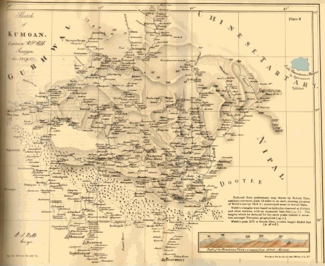
Sketch of Kumoan, 1819
Lipulekh is located at 17,000 ft. and it is a border point between Nepal and Tibet, autonomous region of China. The whole controversy on the illegal occupation of Limpiyadhura-Lipulekh-Kalapani has flared up after the news that India is constructing road on Lipulekh to join India with Mansharovar, Tibet. Indian Prime Minister Nehru, on the apparent request of the then PM of Nepal Matrika Prasad Koirala, had sent armies to Kathmandu on the pretext of modernization of the Nepal Army. These Indian armies, instead of returning to India after the completion of the task that was supposed to be over within one year, stayed in Nepal for more than 18 years. It was only with the continuous effort by Nepal’s Prime Minister Kirti Nidhi Bishta that the Indian Army started pulling out of Nepal in 1969.
The diplomatic maneuver by Nepal’s Prime Minister Kirti Nidhi Bishta at that time is another story with its own sub-plots. After India ignored the frequent requests of Nepal made through diplomatic channels, Prime Minister Kirti Nidhi Bishta had to orchestrate an interview with The Rising Nepal, a daily newspaper from Kathmandu, on the 25th of June 1969. In that interview, Prime Minister Kirti Nidhi Bishta clearly outlined, despite India’s dismay, his arguments for the withdrawal of the Indian Army from all 18 posts. The Indian establishment reluctantly removed its armies from 17 out of 18 posts, but Indians continued to stay at Tilshi Valley in Kalapani. Later, India took several measures in the most wicked manner to change the territory of Nepal. It has renamed a small river at Kalapani as Mahakali, and has tried to portray Kalapani as the origin point for River Mahakali. It has also constructed a small Kali Temple there. This is how India has tried to change the boundary of Nepal.
As per the Nepal-China Treaty of 1960, it emerges without any iota of doubt that China has clearly recognized and respected the fact that Lipulekh belongs to Nepal. After considering the clarity that China had in 1960, it is ominously surprising that China has chosen to stay mum when India constructed a road on Nepal’s land to connect Mansharovar in Tibet. Nepal needs to carefully assess and calibrate its understanding of neighbours – when both neighbours, at least on this one issue, have shown no regard for Nepal’s sovereignty.
Possible Options for Nepal
Presently, Nepal has three possible options to resolve the border dispute with India, and it goes without saying that the first and the best way would be to look for an amicable settlement through a process of dialogue. Nepal had consistently asked for meetings and dialogue with India at various levels but that is not making any headway. We can only hope that better sense prevails in New Delhi and it will agree to sit down for dialogue. In the meantime, Nepal needs to start the process of gathering evidence for its position immediately, by engaging historians, technical experts in GIS and cadastral maps, and diplomats. This would also entail obtaining the authentic copies of maps, agreements and treaties from official archives and national and international libraries. Based on documentary evidence, Nepal would be able to establish an irrefutable case in its favour. If required, the high level dialogue should be led by the Prime Minister himself, or by the Foreign Minister.
Based on the response of India, and the outcome that emerges after bilateral discussion with India, Nepal may also have to seek the assistance of China to resolve this matter – as a second option. As India has displayed discourteous behaviour on the issue, a trilateral meeting may have to be called, involving China. However, India will not readily agree for such trilateral meetings. Still, Nepal can argue that the newly published map of Nepal and its claim over the territory from so long ago will have serious implications and ramifications on point number 28 of the agreement that India and China signed. It is worth reminding both our neighbors that this agreement was one such juncture in history when Nepal stood its ground firmly to reclaim its land.
Nepal needs to do its homework thoroughly, completely and diligently, so as to be able to ask tough questions elicit answers in its favour from its giant neighbours. When China had accepted Lipulekh as a part of Nepal in 1960, what might have prompted it to agree to open a trade link with India via this territory? The agreement by Narendra Modi of with the Chinese in 2015 was clearly without any prior discussion with Nepal and courted controversy due to Nepal’s serious objections. On this, both China and India jointly should have shown the diplomatic maturity to take Nepal into confidence. However, the cold-shouldering and long silence by China on this matter means the way ahead is quite problematic for Nepal. We hope China needs not be reminded of the fact that it was Nepal who strongly stood with China when there were movements that threatened its territorial integrity, particularly the secession of Tibet. Historical facts attest to Nepal's support for the One China Policy. The Tibetan rebel leader Ge Wangdi, belonging to the Khampa rebellion, was neutralized by the Nepal Army at Lipulekh Bhanjyang.
Additionally, the need to respect international law and practice of civilized nations means that India must immediately halt the construction of roads at Lipulekh and there should be a complete moratorium on any new constructions by India until the issue is resolved.
Finally, if none of the above works, the only viable option left for Nepal is to internationalize the border dispute with India and argue its case at every forum. Nepal can certainly raise this issue at United Nations General Assembly and the Security Council. This may not be able to help us to resolve the matter immediately. However, it would help us to make the international community aware of our situation. That would create moral pressure on India to sit down for dialogue, and may also compel China to play a positive role for settlement, considering its clout over India established via trade. Since India is vying for the coveted place as permanent member of the Security Council, it will be morally embarrassing for India not to get support from its next-door neighbour. This move will urge the Indian establishment to find a permanent peaceful solution as soon as possible, instead of lingering on the issue.
Though we are focused only on the dispute concerning Lipulekh, Limpiyadhura and Kalapani at present, there are several reports of land encroachment by India at various places from the East to the West, from the plain region to high mountains. An informal study states that India has shifted its border towards Nepal at 122 places at least. When the desire to find a peaceful solution is rejected frequently by India, internationalization of a border dispute will also open the gate for Nepal to resolve other such disputes. When we fight for our land in international fora, there may arise the need to involve an erstwhile superpower, Great Britain, as well. Being a party to the Sugauli treaty, as a successor and rightful heir of East India Company, it may possess such valuable documents, maps and other correspondence that can help parties to resolve this issue conclusively.
We may be able to re-establish the relationship of bread and daughter (Roti Aur Beti) even if Nepal’s actions, however unlikely, affect this. But if we miss this opportunity of internationalization, the opportunity will be missed forever.
The author tweets at: @Nepaldiary